ST. GEORGE — The majority of Utah is expected to be whitewashed this weekend as a winter storm moves through the state beginning Friday, creating potentially hazardous road conditions into Saturday and Sunday.
Snow will be possible on roadways from the Utah-Wyoming border to as far south as the Toquerville exit on Interstate 15, with accumulations of 6-12 inches along parts of I-15 and mountain routes.
The National Weather Service has issued a winter weather watch in effect from Friday evening through Sunday morning advising of difficult travel conditions, including road snow, slush and low visibility.
Timing
A significant winter storm will impact Utah beginning Friday afternoon and continue through Saturday. Snow will arrive in northern Utah Friday afternoon and slowly move southeast across the state Friday night and Saturday.
Impact
This storm will bring widespread snow showers and road snow accumulations to the vast majority of the state with the exception of some of the lower valleys in the southernmost part of the state.
Significant travel impacts are expected for all mountain routes across the state as well as large stretches of I-15 and Interstate 70.
The Utah Department of Transportation advises motorists to plan for difficult travel conditions. Hazardous conditions include road snow, slush and significant reduction in visibility during the storm.
Routes affected in Southern Utah
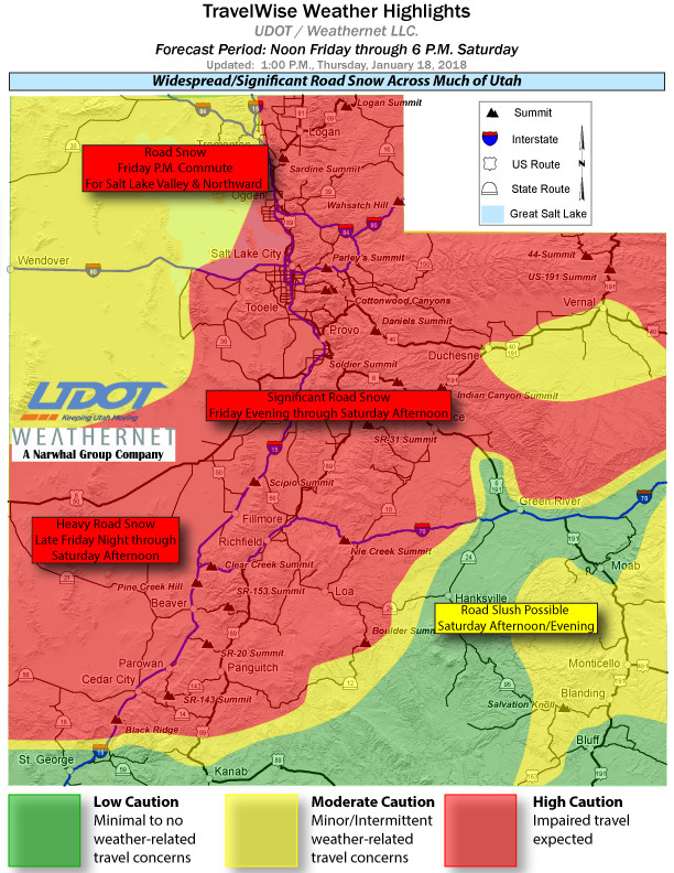
On I-15 from Saturday morning into the afternoon, heavy road snow is expected from Beaver to I-70 junction and Beaver to Cedar City. Road slush is likely from Cedar City to Exit 27 at Toquerville.
Other Southern Utah roadways affected by snow and slush Saturday morning into the afternoon include the following routes:
- State Route 143 over Brian Head Flats, Parowan to Panguitch.
- State Route 153 to Puffer Lake/Eagle Point.
- State Route 14 over SR-14 Summit, Cedar City to Long Valley Jct./US Route 89.
- State Route 20 over SR-20 Summit, between US-89 & I-15 at milepost 95.
- State route 24 over Wayne Summit between Richfield and Loa.
- State Route 12 from US-89 past Bryce Canyon to Tropic.
- State Route 56 from the Nevada state line to I-15.
For a complete list of routes affected by the storm throughout Utah, visit the UDOT website.
Vehicle preparation and safety precautions for winter weather driving.
Getting ready
- Be aware of road conditions. UDOT recommends checking CommuterLink or UDOT’s current road conditions of calling 511 for road and weather conditions before leaving home.
- Clear any frost and snow from the car’s lights and windows. Make an effort to see and be seen while driving.
- Inspect the vehicle’s tires, fluids, wiper blades, lights and hoses. Preventative maintenance may save a car from breaking down and stranding drivers and passengers on the highway.
- Allow for leeway in travel time. Expect to drive slowly in adverse weather conditions. High speeds can lead to skidding off the road and getting stuck in the snow.
When driving
- Take it slow. Drive well below posted speed limits and leave plenty of space between cars.
- Approach intersections, off-ramps, bridges and shaded areas slowly. These areas are hot spots for black ice.
- Slow down in cases of limited visibility and be alert.
- Whether someone drives an elevated SUV or a ground-kissing Toyota Prius, again, UDOT says to take it slow. Just because a truck has 4-wheel drive doesn’t change how it handles on the road, especially when traction goes out the window. Mother Nature is no respecter of automotive diversity.
- Keep the vehicle’s speed down. The faster the car goes, the longer it takes to stop. Be slow on the accelerator or risk having the car skid when the next stop sign appears.
- Do not use the car’s cruise control while ice and snow still abound.
The above recommendations were compiled in 2015 from the Washington County Sheriff’s Search and Rescue website, the Center for Disease Control’s emergency winter weather checklist and the U.S. Search and Rescue Task Force’s website on blizzard preparedness. This is a list of suggestions, in no particular order of priority, and should not be presumed exhaustive.
Email: [email protected]
Twitter: @STGnews
Copyright St. George News, SaintGeorgeUtah.com LLC, 2018, all rights reserved.