ST. GEORGE — Just one day after a hazardous weather outlook was issued for the western two-thirds of Utah, the National Weather Service in Salt Lake City has put out a flash flood watch for central and Southern Utah.
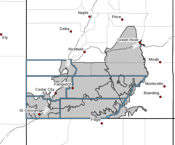
The watch is in effect Friday from 2 p.m. to midnight and covers Utah’s Dixie and Zion National Park, southern mountains, Glen Canyon Recreation Area/Lake Powell, south central Utah and the San Rafael Swell.
Affected cities include St George, Kanab, Escalante, Bullfrog, Loa, Panguitch, Green River, Hanksville and Bryce Canyon.
Scattered showers and thunderstorms capable of producing heavy rainfall will develop this afternoon across the higher terrain, and spread southward across the lower elevations of Southern
Utah during the late afternoon and evening.
Heavy rainfall can lead to rapid onset of flooding, with some of the most prone areas being slot canyons, burn scars, normally dry washes, and low water crossings.
Read more: This is how monsoons could menace communities around the Brian Head burn scar
Water can rise quickly downstream of heavy rain, even when the actual thunderstorm is many miles away. Rock and mud slides, as well as water flowing across roadways, will be possible and could
locally impact travel.
Precautionary preparedness actions
“Turn around, don’t drown” when encountering flooded roads. Most flood deaths occur in vehicles.
Remain alert for flooding even in locations not receiving rain. Dry washes, streams and rivers can become flooded with raging killer currents in a matter of minutes, even from distant rainfall.
Closely monitor weather forecasts and be prepared to take immediate action should heavy rain and flooding occur or a flash flood warning is issued.
The National Oceanic and Atmospheric Association and the National Weather Service safety tips for flash flooding:
- Flash flood waves move at incredible speeds and can roll boulders, tear out trees, destroy buildings and bridges and scour out new channels. Killing walls of water can reach heights of 10 to 20 feet. You will not always have warning that these deadly, sudden floods are coming. When a flash flood warning is issued for your area or the moment you first realize that a flash flood is imminent, act quickly to save yourself. You may have only seconds.
- Most flood deaths occur in automobiles. Do not drive your vehicle into areas where the water covers the roadway. Flood waters are usually deeper than they appear. The road bed may not be intact under the water. Just one foot of flowing water is powerful enough to sweep vehicles off the road. If the vehicle stalls, abandon it immediately and seek higher ground. Rapidly rising water may engulf the vehicle and its occupants and sweep them away.
- Do not hike rivers and especially slot canyons while flash flood warnings are in place.
- Do not hike alone and always tell someone where your group is going.
- Get out of areas subject to flooding, including dips, low spots, canyons and washes.
- Avoid already flooded and high velocity flow areas. Do not try to cross a flowing stream on foot where water is above your knees.
- Be especially cautious at night when it is harder to recognize flood dangers.
- Do not camp or park your vehicle along streams and washes, particularly during threatening conditions.
During any flood emergency, stay tuned to your NOAA weather radio, commercial radio or television. Follow St. George News at STGnews.com and St. George News Facebook for weather alerts and updates relevant to the affected areas. Information from the National Weather Service and disaster and emergency services may save your life.
Email: [email protected]
Twitter: @STGnews
Copyright St. George News, SaintGeorgeUtah.com LLC, 2017, all rights reserved.