ST. GEORGE – The Washington County Commission ratified a protest to the Bureau of Land Management’s proposed final resource management plans at a regular meeting Tuesday.
Commissioners noted that while progress has been made, there are still areas of concern including the proposed northern corridor across tortoise habitat in the Red Cliffs National Conservation Area.
The Bureau of Land Management plans for the Red Cliffs and Beaver Dam Wash national conservation areas affect more than 100,000 acres in the county and stirred controversy during the public comment period that ended last fall.
“The county’s been as proactive as we can be with our local (BLM) office on this,” Deputy Washington County Attorney Eric Clarke said, “and feel like there’s been a lot of really positive changes from the draft plan to this one.”
For example, a proposal for an 87,000-acre wildlife management area has been withdrawn in the proposed final resource management plans; water rights language in the plans has also significantly changed.
“But there’s still aspects of the plans that the county feels like we need to protest,” Clarke said. “Things that are being put in place that would limit BLM’s consideration of the northern corridor are very problematic.”
Commissioner Zachary Renstrom said that language in the proposed final draft is still “more restrictive than wilderness.”
“Theoretically, if someone wanted to go up there hunting, they’d have to shoot the deer on the trail and hope the deer dropped dead on the trail,” Renstrom said.
“They restrict camping, they restrict rock climbing, they restrict hiking, they restrict – just lots of different activities that most people in this county love, using those lands,” Renstrom said.
While a lot of progress has been made, Commissioner Victor Iverson said it’s very important to protect the citizens’ standing by protesting the BLM plans.
Read more: BLM and public lands: Officials offer mixed reviews of proposed resource management plans
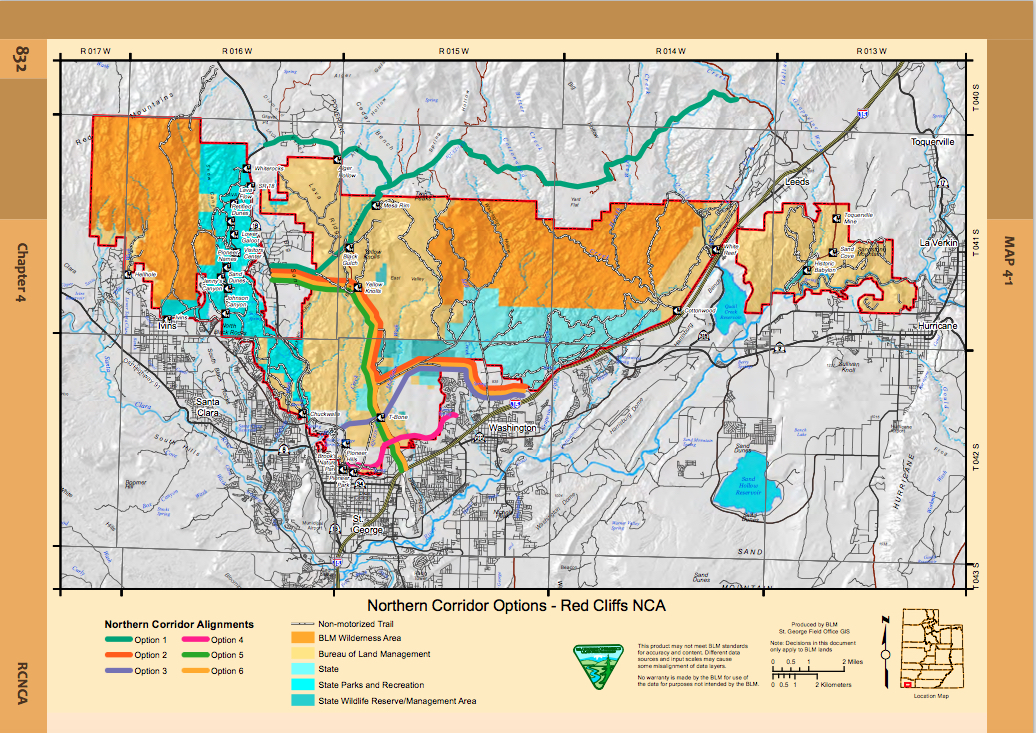
The proposed resource management plan for the Red Cliffs National Conservation Area violates both the letter and the spirit of the Omnibus Public Land Management Act of 2009, or OPLMA, a directive to the Secretary of Interior to identify alternatives for a northern transportation route, county officials said in the protest.
Alternative D in the management plans, which is not the BLM’s preferred alternative, is the only one that included any option for a northern transportation route.
“It is also the county’s position that including routes in one alternative of the RMP does not satisfy OPLMAs mandate to study one or more alternatives in the travel management plan,” the protest states.
“Although studying routes in the RMP is not the usual planning process, acts of Congress that specify a planning requirement are sufficient to change the normal planning process. Every alternative in the draft RMP should have included ROV/ provisions that would have allowed the consideration of northern corridor routes.”
The county is concerned that the environmental analysis for Alternative D does not provide an accurate estimate of a single northern corridor route because it analyzes all of the proposed routes collectively rather than individually.
“Consequently, it analyzes the possible disturbance of thousands of acres, where the county’s preferred alternative would only disturb a few hundred acres.”
The protest period for the proposed resource management plans for the Beaver Dam Wash and Red Cliffs national conservation areas; proposed amendment to the St. George Field Office Resource Management Plan; and abbreviated final environmental impact statement ended Oct. 3.
The full text of the county’s protest can be found here.
Email: [email protected]
Twitter: @STGnews
Copyright St. George News, SaintGeorgeUtah.com LLC, 2016, all rights reserved.
And the feds just can’t “understand” why the citizens and governing bodies in the counties don’t want them running things. While I’m not in favor of this latest craze of turning over all federal government lands to states, (like any other nut case ideas,) I do not believe that the feds should be able to dictate all that they do. Good lord, next they will be telling the turtles where they can and can’t poop.
Actually I wouldn’t be surprised if the feds haven’t already gotten ready to pass a pooping regulation bill
This comment by Commissioner Renstrom is interesting: “Theoretically, if someone wanted to go up there hunting, they’d have to shoot the deer on the trail and hope the deer dropped dead on the trail.” He was alluding I guess to the fact that the hunter could not take an ATV into a restricted area to get the animal. Perhaps the good commissioner, and others who like to reference the pioneer leaders whenever that suits their position, might want to remember that those good pioneer folks would have rode a horse or hiked in to cut up and pack out the dead animal. It’s these less than hearty types who have to rely on ATVs apparently.
He may be speaking of the “Lowland area” of the RCNCA being restricted to on trail hiking only.
He isn’t talking about road hunters too lazy to get off their ATV (though that is a problem). He’s talking about proposed BLM policies that would turn areas currently open to hunting and walking off-trail into areas that can only be used by staying off the trail. Clearly you can’t hunt there if you can’t leave the trail, which means a major change in the current usage of the areas with that proposed change. In other words the exact approach the good pioneer folks used would now be outlawed as well.
Federal lands and BLM lands are just used to back bonds so that the president can continue to spend lots and lots of money. so if you really want to keep your land they need to go back to the states and the states need an excuse and that excuse is, “the people want to use the lands” so we can either give the land to countries by allowing them to be currency or we can give the land back to the states.
This is exactly why I oppose turning BLM land over to the greedy, short sighted developers and their cronies in all levels of government. Just say no.
Who is proposing Option 1 (the northern-most route, green on the map) and why? That option is INSANE and will cause massive northward expansion in Washington County. It would be convenient for a few, but only when traveling towards Salt Lake. People commuting from Santa Clara / Ivins to Hurricane or even the east side of St. George wouldn’t benefit at all.
Is the BLM pushing it? Or is the County Commission? I’d love to know what their motives are.
Option 3 (purple on the map) is the only route that makes any sense. None of the other routes offer any mass benefit from a transportation perspective. But Option 3 helps the most amount of people get to and from the most amount of places from east to west and vice-versa. Yes, it goes through the tortoise preserve, but if you drive out the dirt road at the north end of the industrial park (towards the old turkey farms) and stop a few hundred feet south of the substation ( 37.135905, -113.563303) and look straight northeast and west-southwest, you’ll see there’s nothing there. Option 3 isn’t the end of the world and won’t have any more impact on the tortoises OR development than the Pioneer Parkway. There is zero development between SR-18 and the water tower at 500 East on Pioneer Parkway (except the blasted WCWCD Taj Mahal). So it isn’t a foregone conclusion that Option 3 will bring massive development to the area it goes through. It’s the only viable option for a northern corridor.
Agree that Option 3 makes the most sense.
None of the roads make any sense. The Reserve was established to remain “roadless” as the HCP clearly states except for the few existing roads when the habitat was established. Growth in Washington County as shown by the county’s own 2015-2040 transportation plan and expressed in public meetings is concentrated in the St. George area, southern part of the county and toward Hurricane and that’s projected into the future. There is little growth planned in the northern areas of the county that would necessitate a Northern Corridor. Removing the $94 million shown on the transportation reports charts for the preferred NC (Option 3) would remove the shortfall for roads in the area and eliminate or reduce the need for the Proposition 1 on the November ballots (local option sales tax), which even with the $94 million is a something voters should reject.