UPDATE 3:47 p.m. The National Weather Service has issued a “Flash Flood Warning” for west central Kane County and east central Washington County. Very heavy rainfall has occurred over the headwaters of the north fork of the Virgin River which flows downstream through the Narrows Section of Zion National Park. Additional thunderstorms will continue to produce very heavy rainfall across Zion National Park eastward into western Kane County through 5 p.m. Flash flooding is expected through the Narrows section of Zion and will likely develop through additional slot canyons within Zion National Park eastward through western Kane County. See map added below.
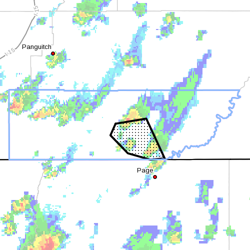
UPDATE: 1:32 p.m. The National Weather Service has issued a “Flash Flood Warning” for central Kane County. Thunderstorms producing very heavy rain across Wahweap and Warm Creeks. Flash flooding can be expected from the headwaters downstream to Lake Powell. See map added below.
SOUTHERN UTAH – Southern Utah has not seen the last of its challenging storms. The National Weather Service has issued a “Flash Flood Watch” for many areas throughout Utah, in effect from noon to 10 p.m. today.
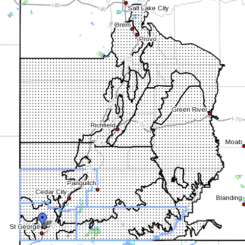
Watch areas: Southern Wasatch Front – Wasatch Mountains south of Interstate 80, Wasatch Plateau – Book Cliffs, Castle Country, San Rafael Swell, Sanpete-Sevier Valleys,west central Utah, southwest Utah, Utah’s Dixie and Zion National Park, south central Utah including Glen Canyon Recreation area, Lake Powell, central and southern mountains.
Conditions: Numerous showers and thunderstorms will develop over the southern 2/3 of Utah this afternoon in an extremely moist air mass. Because of this, the storms will be rather efficient rain producers and heavy rain is possible with any storms that develop.
Most threatened: The flash flood threat is greatest over burn scars, as well as slot canyons and normally dry washes. Small streams could experience significant rises as well. Urban flooding is possible.
Precautionary and preparedness actions
- A flash flood watch means that conditions may develop that lead to flash flooding. Flash flooding is a very dangerous situation. Most flood deaths occur in automobiles.
- Do not drive your vehicle into areas where the water covers the roadway. Flood waters are usually deeper than they appear. Just one foot of flowing water is powerful enough to sweep vehicles off the road.
- Using cruise control in the rain can cause your vehicle to hydroplane. Be aware of pooling water on highways ahead of you and slow down.
- Do not hike rivers and especially slot canyons while flash flood warnings are in place.
- Do not hike alone and always tell someone where you and your buddy and others are going.
Turn around, don’t drown.

Related posts
- Injuries sustained when car hydroplaned on I-15 Cedar
- Record rainfall in Cedar City results in ‘massive flooding’ throughout city; STGnews Photo Gallery
- UPDATED: Summer storm floods Coral Canyon homes; STGnews Videocast
- Flash flooding meets River Road near Southern Parkway; Videocast, STGnews photo gallery
Email: [email protected]
Twitter: @JoyceKuzmanic
Copyright St. George News, SaintGeorgeUtah.com LLC, 2013, all rights reserved.
